

February Thaw Could Melt Most of Central, Eastern U.S. Snowpack by Late-Week
Following back-to-back winter storms – Liam and Mateo – from early last week through last weekend, many residents of the Northeast, Midwest, Plains and Rockies are feeling snow-fatigued after days of shoveling and snowblowing driveways and sidewalks. But the forecast calls for warmer temperatures later this week, which will melt most of this remaining snowpack.
Chicago tied its streak of consecutive days with measurable snow Sunday, the ninth day in a row with at least 0.1 inches of snowfall at O'Hare International Airport. This was a sharp contrast to last winter, when January and February featured no snow cover of at least one inch, a record snowless streak in the Windy City.
While not a record, Syracuse, New York, saw measurable snow for 13 consecutive days ending Feb. 10, its longest streak since January 2011. Many western and central New York residents were getting tired of snow removal.
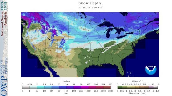
The deepest snowpack as of Tuesday morning was found in the Washington and Oregon Cascades, Sierra Nevada, northern and central Rockies, upper Midwest, Great Lakes, northern New England and New York's Adirondack Mountains.
An estimated 45 percent of the Lower 48 was covered by snow early Tuesday, according to NOAA's National Operational Hydrologic Remote Sensing Center.
 Estimated snow depth as of 1 a.m. EST Feb. 12, 2018.
(NOAA/NOHRSC)
That map will likely look much different by this weekend as warmer temperatures engulf the central and eastern states.
February Thaw to Melt Snowpack
The weather pattern will undergo a temporary change by the middle of this week as the jet stream takes a southward dive over the West, resulting in a northward bulge across the eastern half of the country.
A warm, southerly flow will develop beneath that northward bulge in the jet stream and allow warmer temperatures to infiltrate the Plains, Midwest and East for the second half of the week.
 A northward bulge in the jet stream will allow warmer temperatures to infiltrate the central and eastern United States during the second half of this week.
Here's a look at the day-by-day details of this upcoming warm-up.
- Wednesday: High temperatures 10 to 25 degrees above average will stretch from the Front Range of the Rockies to the East Coast. The warmest regions, relative to average, will likely be the upper Midwest, mid-Mississippi Valley and the central and southern Plains.
- Thursday: Cooler temperatures will arrive in the Rockies and northern Plains, but it will remain mild from the southern Plains and the lower and mid-Mississippi Valley to the Midwest and East. The warmest temperatures, as high as 20 to 30 degrees above average, will be found from southern New England to the mid-Atlantic, Ohio Valley and Appalachians.
- Friday: While much of the Midwest drops closer to average, the core of the above-average warmth will hang on along the East Coast from New England to Florida and also along the northern Gulf Coast, where readings will generally be 10 to 25 degrees warmer than average. Some parts of southern Virginia and the Carolinas could be up to 30 degrees above average.
A few daily record-warm temperatures are even possible, mainly from Florida into the mid-Atlantic Thursday and Friday, where highs in the 70s and 80s are expected.

Forecast Highs
Although temperatures will briefly cool down by this weekend, a similar but longer-lasting pattern change is likely to commence early next week and persist into late February. That means more mild weather may be in store over the next couple of weeks east of the Rockies.
Give that snowblower a much-needed break for now, but don't put it away just yet. March can still bring snowstorms from the Mountain West and the Plains into the Midwest and Northeast, and on more rare occasions, parts of the Deep South.