

Flooding downpours to disrupt travel, outdoor plans in southeastern US into late week
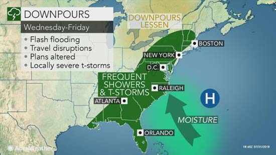
Downpours will plague the southeastern United States into the end of the week, bringing a heightened risk of flooding and disruptions to daily routines.
A stream of tropical moisture from the Atlantic Ocean and Gulf of Mexico will pump northward across the southern Atlantic Seaboard and into the Northeast through the week, leading to day after day of showers and drenching thunderstorms.
The pattern will bring downpours to a much larger area of the Southeast than the hit-or-miss storms that typically occur during the summer months.

AccuWeather Senior Meteorologist Frank Strait is concerned that the downpours will be slow moving and repeat over the same areas, resulting in excessive rainfall and flooding.
For most areas, rainfall totals for the entire week will generally be around 2-4 inches.
However, in areas hit with repeated downpours or where storms linger, rainfall for the week can top 6 inches.
A portion of this rain can fall within a few hours, which can quickly flood streets and trigger rapid rises on creeks and streams.

“The heaviest rainfall and storms will be from the central Gulf states to the eastern Tennessee Valley and Appalachians, especially the eastern slopes and foothills in the Carolinas and western Virginia,”said AccuWeather Lead Long-Range Meteorologist Paul Pastelok.
In the southern Appalachians, mudslides will be possible.
People with outdoor plans or those who live in flood-prone areas should keep up-to-date on the latest flood watches and warnings on the AccuWeather app. AccuWeather MinuteCast® can tell you exactly when rain will begin and how long it will last in your location.
It is not out of the question for some of the strongest storms to produce winds strong enough to topple trees and power lines. Anyone outside should seek shelter immediately after thunder is heard or lighting is seen.
Motorists with daily commutes or longer road trips across the region are advised to slow down in the downpours, as visibility will be reduced and there will be a heightened risk of hydroplaning at highway speeds. This includes on interstates 10, 20, 40, 55, 59, 75, 81, 85 and 95.
Air travelers into and out of Atlanta and other major hubs in the region may be significantly impacted with delays and cancellations amid the stormy pattern.

People heading to the Atlanta Braves game on Wednesday night should bring along rain gear and prepare for possible delays, similar to what occurred on Tuesday night.
While wet weather may not be quite as frequent along the coast, people along the Southeast beaches will need to be wary of an additional hazard—rough surf.
An upside to the rainy pattern may be that temperatures will be much lower than usual, with highs generally in the 80s as opposed to the more typical 90s F.
“By the weekend, thunderstorm activity should finally begin to be suppressed,”Strait said.
The less-extensive coverage in storms will also help temperatures to climb back to more typical early August levels this weekend.
The Southeast is forecast to remain much less rainy and sunnier into next week.