

Why flooding from this week's massive storm won't be as severe as last month
A massive spring storm unfolding in the central United States will be second only in strength to the 'bomb cyclone' that hit during the middle of March. Will this storm cause a repeat of the significant stream and river flooding triggered by that cyclone?
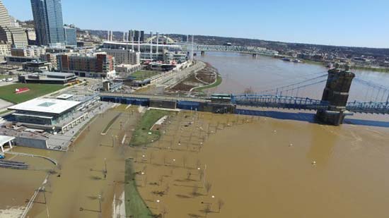
The March 'bomb cyclone' caused a rapid meltdown of existing snow cover combined with torrential rainfall.
In contrast, rain associated with this week's storm is not going to be as widespread and snow farther north is not expected to rapidly melt.
A sweep of dry air from the southwest should keep rain confined to a very narrow zone over the central Plains and middle Mississippi Valley or cause that rain to be brief.
Where the bulk of the rain falls with this week's storm, there is no snow on the ground and the ground has thawed to allow some retention of moisture.
Even though rivers are high and some are currently still at major flood stage, a new round of record river flooding caused by this week's storm is not expected.

This week's storm will unload up to 30 inches of heavy, wet snow on parts of the northern Plains and northern Rockies. However, even though this snow may contain up to 4 inches of water, it will not all melt at once.
The melting snow by itself will lead to a new surge of water into area streams and rivers, which can slow the rate of recession, prolong existing flooding or perhaps cause a second crest.
A second crest is likely along portions of the James and Big Sioux rivers. Meanwhile, along the Red River of the North, it may be several more weeks before levels dip below flood stage. Fluctuations in water levels are likely along the Missouri and Mississippi rivers.
In most cases, that second crest is likely to be substantially lower that that of the past few weeks or has yet to occur from rain and snowmelt that is still cycling downstream from storms and snow earlier this year.
"Chilly air will follow the storm in the short term and a gradual thaw of the snow cover without heavy rain is forecast in the coming days, which is some good news,"according to AccuWeather Senior Meteorologist Dale Mohler.
There is some more good news.
No big rainstorms are heading for the northern Plains, northern Rockies and the bulk of the central Plains for the next week or so since the storm track will shift.
Episodes of heavy rain are likely farther south over the Central states during next couple of weeks, but these will be south of the heavy snow area from this week's storm.
However, there are still likely to be some bullets to dodge over the U.S. in general in terms of flooding this spring.
In areas across the South Central and Southeastern states, ongoing rainfall may be frequent enough to initiate new river flooding in some cases and most likely lead to many sporadic incidents of urban and small stream flooding.
In the long-term, areas across the northern Plains, Upper Midwest and northern New England may remain a loaded gun for a while, should a crazy storm with heavy rain come calling for a time after the last inches of snow have melted.