

Spring Flooding Could Lead to Large Gulf of Mexico 'Dead Zone' This Summer
The Gulf of Mexico “dead zone” could be large this summer after spring flooding produces higher-than-average discharges of nutrients and freshwater from the Mississippi River, NOAA warned in its National Hydrologic Assessment.
More historic, widespread flooding is expected in the central United States this spring, according to NOAA's outlook, and this is anticipated to create conditions
"highly conducive to hypoxia development and lead to an above-average to large hypoxic zone in the northern Gulf of Mexico this summer."
In the northern Gulf of Mexico, a large hypoxic area – an area which features such low oxygen levels that it's unable to support marine life – forms each summer and often exceeds 5,000 square miles.
This hypoxic area is often called the dead zone and is highly influenced by rainfall patterns in the Mississippi-Atchafalaya River Basin, which drains more than 41 percent of the Lower 48 states.
The more rain that falls over that basin, the more nutrients and freshwater deposited into the Gulf of Mexico, leading to the development of hypoxia. Therefore, the spring flooding risk in the Mississippi-Atchafalaya River Basin is a good indicator of the potential size of the dead zone in the upcoming summer.
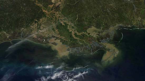
Areas of sediment in the northern Gulf of Mexico were visible in NASA satellite imagery from March 22, as indicated by the brown areas at the mouths of the Mississippi and Atchafalaya rivers, south of Louisiana.

Brown areas at the mouths of the Mississippi and Atchafalaya rivers, south of Louisiana in the northern Gulf of Mexico, show areas of sediment on March 22, 2019.
The U.S. Geological Survey will measure discharge amounts and corresponding nutrient concentrations from those rivers in early June, and these data will be used by NOAA and other outlets to release dead-zone forecasts for the Gulf of Mexico.
The actual size of the dead zone will be measured this summer and compared with the forecasts, NOAA said.
The largest Gulf of Mexico dead zone since mapping began there in 1985 was 8,776 square miles in July 2017. That's about the size of New Jersey.

At 8,776 square miles, July 2017's dead zone in the Gulf of Mexico was the largest ever measured.
It should be noted, however, tropical storms and hurricanes can locally disrupt dead-zone formation and maintenance, so an active early hurricane season could cause the dead zone to be much smaller than predicted.