

Temperatures and Precipitation the Rest of Summer
At a Glance
- Warmer-than-average conditions may give way to below-average temperatures in parts of the nation's northern tier July-August.
- Many areas in the West will experience above-average temperatures for the rest of summer.
- Rainfall could be above average in the Southwest and mid-Atlantic through September.
For the rest of the summer, temperatures in portions of the central and eastern states may start out warmer-than-average but then transition to below average, while much of the West is expected to see above-average warmth, according to the latest outlook from The Weather Company, an IBM Business.
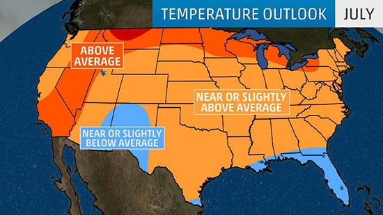
In July, parts of the nation's northern tier and the West are the most favored areas for above-average warmth, including a swath from the Great Lakes westward to the northern Plains and the northern Rockies, and then southward into Nevada and southern California.
Many other areas in the eastern half of the nation are forecast to see temperatures near or slightly above average for July. The exceptions are parts of the Gulf Coast and Florida where it may be slightly-cooler-than average, although typical summertime warmth and humidity will still be in place.

The expectation of warmer-than-average conditions across the northern tier of the U.S. in July is because a positive North Atlantic Oscillation (NAO) pattern will be in place, which is indicative of a strong polar vortex.
"If we look at the temperature pattern during July in a positive NAO pattern we can see a warm north, cool-south pattern. It is difficult to go against this idea at this point," said Dr. Todd Crawford, chief meteorologist with The Weather Company.
As we transition to August, the potential emergence of El Niño and its impact on tropical activity in the northwest Pacific Ocean may influence the jet stream pattern downstream in the United States, and therefore, temperatures as well.
"We’ve cooled off August a bit in the East as we expect the emerging El Niño forcing to continue to strengthen and enable an active late-summer period in the northwest Pacific tropics," Crawford said.
As a result, the Great Lakes and upper Midwest are expected to see below-average temperatures in August, with near or slightly below average temperatures in many other eastern locations. In the West, the opposite is expected with widespread hotter-than-average conditions forecast.

Looking ahead to September, there are no major areas of above or below-average temperatures forecast at this time. A large swath of the nation is forecast to see near or slightly above-average temperatures. South Georgia and Florida are the most likely locations for above-average warmth, and parts of the Southwest may be slightly cooler-than-average.
Rainfall Outlook Next Three Months
The mid-Atlantic, Southwest and the central Rockies are forecast to see above-average precipitation the next three months, according to an outlook from NOAA.
In the Southwest and Rockies, monsoonal moisture and the remnants of eastern Pacific tropical systems may increase rainfall chances July-September, tipping the scale towards wetter-than-average conditions.

Drier-than-average conditions are most likely July-September from the eastern half of Texas to the lower-Mississippi Valley. The Pacific Northwest is also forecast to see below-average rainfall, though summer is a typically dry time of year for that region.
Keep in mind, these outlooks are overall trends. A cold front or an upper ridge of high pressure can lead to a brief period of colder or warmer weather, respectively. The same front or area of high pressure can bring a brief period of enhanced precipitation or dry spell that may or may not be indicative of the overall trend we're anticipating.