

Waters off US East Coast may give birth to tropical storm west of Bermuda
While there is no direct threat to land, nearby Atlantic waters off the East Coast of the United States may give birth to a tropical depression or storm during the 2018 hurricane season over the next few days.
This feature may join Tropical Storm Beryl, which formed in the south-central Atlantic on Thursday.
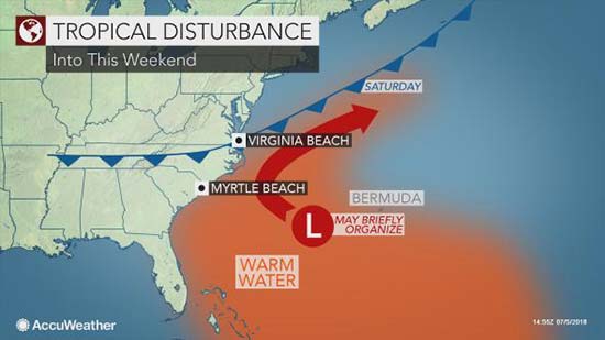
"We are monitoring an area of disturbed weather a couple of hundred miles south of Bermuda at this time,"according to AccuWeather Meteorologist Max Vido.
The potential formation zone is close to the Gulf Stream, which is a continuous current of warm water that originates from the tropics. Waters along much of the Atlantic seaboard are much above average for this time of the year.
"As this disturbance drifts westward, it may enter a zone of low wind shear and begin to develop some spin late this week,"Vido said.
Wind shear is the change in wind direction and increase in speed at different layers of the atmosphere. A tropical storm is more likely to form in a low wind shear zone, rather than a high wind shear zone.
Steering winds are likely to increase, pick up the feature and pull it northward early this weekend. Later this weekend into next week, these steering winds will guide the feature northeastward.
"The only way this feature would impact the U.S. is if it became well-organized, such as a strong tropical storm,"according to AccuWeather Senior Meteorologist Dan Pydynowski.
A strong tropical storm might produce enough winds to generate rough seas and surf along the mid-Atlantic and New England coasts, as well as Bermuda, while a poorly organized feature would not.
"If there is going to be a period of moderate to rough surf, it would be this weekend,"Pydynowski stated.
The nearshore Atlantic feature may pass close enough to southeastern Newfoundland to bring part of the Canadian province a period of drenching rain, gusty winds and rough seas on Tuesday, before diminishing over colder waters.
This loop captured on Thursday morning, July 5, 2018, shows much of the Atlantic basin, including the Gulf of Mexico in the upper left and the Caribbean Sea left of center. Two features are under investigation at this time. One is several hundred miles to the east-southeast of Cape Hatteras, North Carolina, and the other is over the south-central Atlantic in the lower left of the image. (GOES-E/NOAA)
In addition to Beryl and the potential depression near Bermuda, disturbances will also continue to push westward from the Atlantic to the northern shore of the Gulf of Mexico.
While these features are expected to remain too close to land to develop, they will produce rounds of drenching rain across the Deep South into this weekend.
The next names on the list of tropical storms for the 2018 Atlantic hurricane season are Chris and Debby.
Following Tropical Storm Alberto, which developed during Memorial Day weekend, there were no tropical storms over the Atlantic basin during June for the first time since 2014.
AccuWeather Lead Hurricane Forecaster Dan Kottlowski has lowered the original forecast of named storms for 2018, but this does not imply there cannot be high-impact hurricanes later in the season.